

What are the US and Australian military forces agreeing to currently? What the specific implications of this agreement?
TEAMS of US and Australian officials are finalising a series of agreements, to be signed at this month's AUSMIN summit, that will give US forces greater access to Australian military bases. They will result in a significant escalation of military co-operation, including more visits by US ships, aircraft and troops, and their forces exercising here regularly.
What is the name of the summit where Australia's Defense Minister and the US's Secretary of Defense will meet?
AUSMIN summit
Which country is the US specifically reacting to?
China
What are the US planners looking to achieve with this agreement regarding troop movement?
As US planners looking for ways to move forces around the world more effectively broke the globe down into regions, Australian officials worked closely with them on the Asia-Pacific.
What are other key areas of discussion at the summit?
Other key areas for discussion at the talks will be cyber security, progress in Afghanistan and the state of the Joint Strike Fighter project.
What does this agreement mean for Australia's future in the Regional and Global context?
this agreement ensures that Australia's Defence network and connections with other countries will be a lot stronger - especially the US. it also means we will have a "big brother" (US) and will be able to make more rash decisions involving other countries if need be. it is strengthening our alliance with the US which is beneficial for the country.
Subscribe To
Wednesday, September 7, 2011
Monday, September 5, 2011
Source A-C
What is the predicted population growth rate in 2030?
What is the predicted population growth rate in 2030?
0.75%
What is the predicted population change in 2030?
60 million
What region of the world is predicted to have the greatest gross increase in percentage between 1800 and 2050?
South and Central Africa
Source D
How many males and females are there in Ethiopia for the age range 60-64 in the year 2000?
Source D
How many males and females are there in Ethiopia for the age range 60-64 in the year 2000?
500 000
How many males and females are there in Italy for the age range 60-64 in the year 2000?
1.8 million
Why do you think that there is such a difference between these two countries?
because etheopia is a developing nation and has a larger population.
Source E
What is located at GR831979?
Source E
What is located at GR831979?
Dicks Hill
What is the highest point at AR7997?
490
What is the contour interval for the map?
10 metres
What physical feature is located at GR820975?
wet swamp
Approximately how far is the Laurieton Sporting Complex from Hanleys Point on the Camden Haven Inlet?
Give the GR for the North Haven Public School.
GR829005
What is the highest point at Camden Head? Give the height and GR.
Laurieton 79m GR847986
Go Back To Where You Came From Reflection
- What is your initial reaction to the show?
- What percentage of immigrants are refugee?
- Why does such a small number of people make for such a big deal both politically and in the media? (Give your opinion)
- Where does Australia rank among countries accepting refugees?
- To what extent do we have an obligation to help other people suffering in the world? (your opinion)
- How much extra support do refugees receive in comparison to other Australian citizens?
- How many Asian nations have signed the UN Refugee Convention?
- Why is it important to note that Malaysia has not signed the UN Refugee Convention? What does this mean for refugees in Malaysia?
Monday, July 25, 2011
Australia may be a Nuclear target - Kevin Rudd
1. What title does Kevin Rudd have in the Australian Government? Explain what this role entails.
Kevin Rudd is the Foreign Affairs minister for the Australian government. this involves interacting with various countries around the world and keeping an eye on things such as this imminent threat to Australia in the form of nuclear weapons.
2. What is Kevin Rudd's concern?
Kevin Rudd's concern is that North Korea's nuclear missiles and weapon programs are a direct threat to Australia. he believes that North Korea are "detached from reality" and are chasing after their own goals and endeavours and only doing what will benefit them. an example is their lust to continue with their uranium powered weapons program.
3. What forum was he at to express his concerns?
Kevin Rudd was at the ASEAN region forum ministers "meeting" in Nusa Dua, Bali. the other foreign ministers of the organisation were also present.
4. What actions have North Korea performed recently which have Rudd alarmed and the region lacking stability?
North Korea have recently torpedoed a South Korean naval frigate and also shelled civilians' homes across the border which is an act of unnecessary violence that is worrying for the rest of the world. they have also defied two UN security council resolutions by pursuing an enriched uranium weapons program
5. What is a 'direct threat' to Australia according to Rudd?
a direct threat to Australia according to our foreign affairs minister Kevin Rudd is the long range North Korean missile program. "Its a serious matter; it’s not out there on the margins of our national security concerns; it’s real and I reflected those concerns to the North Koreans today".
6. What do you think that Rudd is trying to accomplish diplomatically by calling out his North Korean counterpart publicly? How does this relate to Australia's relationship and role in the region?
i think that Rudd is trying to raise the awareness of this threat. he's trying to bring it out and put it in the spotlight so other countries who are at risk can also see the dangers North Korea pose. this also puts Kevin Rudd in the spotlight and shows that he is worried not only for his countries sake but for our allies in the region. it shows that Australia is a wary country and isn't going to let a risk like this simply drift away.
7. How does this relate to Australia's relationship to major allies?
this instance shows to Australia's major allies that we are investigating this matter, our allies know we are being cautious as we should be which is a good thing. it also makes them more wary of the situation and the possible threat to their country as well. Australia is being seen as the country that is questioning North Korea's weapons program which personally i think other nations have been thinking about as well. Kevin Rudd has simply put it out there to debate about.
Sunday, July 24, 2011
Foreign Aid Review
1. make dot points on the article:
i think that the author is trying to say to the reader that Australia is using an obsurd amount of money to support countries in need such as Indonesia and PNG when really some of them (Indonesia) don't really need any help as they are richer that us when it comes to reality. the author is giving us the facts about Australia's economic situation in terms of Aid and ecenomic growth and how they interrelate with each other. despite this evidence that contradicts the intensions of the government in providing aid for other countries, i think that what we are doing as a country is good for the economy and in a way shows to the world that we are making the effort to help people we believe are in need. i think we should keep doing what we are doing for the meantime untill we have more relevent information on the topic at hand that can be used for the benefit of the country and the country that is being cared for.
3. Why do you think Australia is giving more Aid?
i think australia is giving moe aid because it feels like it's not giving enough to make a difference. a perfect example is our programs in PNG which is one of the most recognised in the world and yet since it started the country has barely changed in terms of ecenomic growth and living standards. the solution to this problem hasn't been found yet, personally i dont belive the answer lies in money as that has already proved itself to be useless.
What would be the benefits of such a policy?
this policy is not only going to be something that helps people who are in great need but it makes us as a country look good in the eyes of other countries such as the USA and the united kingdom. people from countries around the world would admire our generosity and think of us in a good way if they previously had not. also the countries we are helping would be forever greatful for what Australia has done.
What would be the negatives?
less money for Australia is one of the main negatives of this policy. things like infrastructure, our own instinces of unemployment and homlessness and the like, need to be supported as well and many would argue that they deserve to be treated before people overseas. personally i believe that Australians do take a lot of the things we have access to for granted. people overseas are a lot worse off then we are and i still think this policy should go ahead as it may provide peole in a more desperate situation with the help they need to survive.
- in the past 5 years our overseas aid budget has doubled and in the next 5 years it will double again
- by 2015 we'll be spending 8 billion dollars a year helping people overseas
- the report Kevin Rudd undertook along with a panel of experts last year about our foreign aid policy came back recently. neither the panel's report or the governments response answers the bigger question about the purpose of our aid program and why it's growing so fast
- 7 percent of our aid program is in emergency relief
- our aid program is aimed to help people who live on less than $1.25 a day
- In 1981, 54 per cent of the world's people lived in extreme poverty. By 2005 this had fallen to 25 per cent. In 2015 it will be less than 15 per cent, according to the World Bank
- poverty is not being beaten by aid but by ecenomic growth
- economic growth requires a confluence of factors such as social, political and technological, to start whole populations moving from semi-subsistence farming to paid work
- the alchemic growth depends on these factors
- Australia's aid program to PNG has and still is one of the biggest and most innovative programs in the world. even still, PNG has not made any sort of progress since it's independence in 1975
- Australia view some countries such as Indonesia as poor countries when really they are richer than us. Measured in purchasing power parity terms, which avoids exchange rate distortions and gives the truest index of relative economic weight, Indonesia's GDP is now significantly larger than ours
i think that the author is trying to say to the reader that Australia is using an obsurd amount of money to support countries in need such as Indonesia and PNG when really some of them (Indonesia) don't really need any help as they are richer that us when it comes to reality. the author is giving us the facts about Australia's economic situation in terms of Aid and ecenomic growth and how they interrelate with each other. despite this evidence that contradicts the intensions of the government in providing aid for other countries, i think that what we are doing as a country is good for the economy and in a way shows to the world that we are making the effort to help people we believe are in need. i think we should keep doing what we are doing for the meantime untill we have more relevent information on the topic at hand that can be used for the benefit of the country and the country that is being cared for.
3. Why do you think Australia is giving more Aid?
i think australia is giving moe aid because it feels like it's not giving enough to make a difference. a perfect example is our programs in PNG which is one of the most recognised in the world and yet since it started the country has barely changed in terms of ecenomic growth and living standards. the solution to this problem hasn't been found yet, personally i dont belive the answer lies in money as that has already proved itself to be useless.
What would be the benefits of such a policy?
this policy is not only going to be something that helps people who are in great need but it makes us as a country look good in the eyes of other countries such as the USA and the united kingdom. people from countries around the world would admire our generosity and think of us in a good way if they previously had not. also the countries we are helping would be forever greatful for what Australia has done.
What would be the negatives?
less money for Australia is one of the main negatives of this policy. things like infrastructure, our own instinces of unemployment and homlessness and the like, need to be supported as well and many would argue that they deserve to be treated before people overseas. personally i believe that Australians do take a lot of the things we have access to for granted. people overseas are a lot worse off then we are and i still think this policy should go ahead as it may provide peole in a more desperate situation with the help they need to survive.
Wednesday, May 4, 2011
Mapping
1. What is it about the pressure system stalled over Australia that relates to the weather over the next 4 days?
high pressure system
2. What is the air pressure in each of the next 4 days for each of the capital cities? How does this correspond with the predicted weather for these cities?
THURSDAY
Sydney - 1020 Hectopascals
Adelaide - 1030 Hectopascals
Melbourne - 1026 Hectopascals
Brisbane - 1018 Hectopascals
Perth - 1022 Hectopascals
Darwin - 1016 Hectopascals
Hobart - 1024 Hectopascals
FRIDAY
Sydney - 1018 Hectopascals
Melbourne - 1027 Hectopascals
Brisbane - 1016 Hectopascals
Adelaide - 1027 Hectopascals
Perth - 1024 Hectopascals
Darwin - 1012 Hectopascals
Hobart - 1024 Hectopascals
SATURDAY
Sydney - 1018 Hectopascals
Melbourne - 1020 Hectopascals
Brisbane - 1017 Hectopascals
Adelaide - 1020 Hectopascals
Perth - 1024 Hectopascals
Darwin - 1012 Hectopascals
Hobart - 1016 Hectopascals
SUNDAY
Sydney - 1016 Hectopascals
Melbourne - 1020 Hectopascals
Brisbane - 1017 Hectopascals
Adelaide - 1020 Hectopascals
Perth - 1016 Hectopascals
Darwin - 1012 Hectopascals
Hoabrt - 1024 Hectopascals


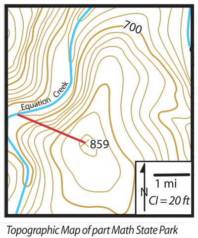
1. What is the contour interval (sometimes abbreviated CI)? Convert to metric.
the contour interval is 20 feet.
2. What is the scale of the map? Convert it into the metric system.
the scale of the map is 1 cm:1.6 kilometres
3. What is the gradient of the line? Calculate in metric system.
121 feet = 36 metres, 2 miles = 3200 metres == gradient is 0.01125

high pressure system
2. What is the air pressure in each of the next 4 days for each of the capital cities? How does this correspond with the predicted weather for these cities?
THURSDAY
Sydney - 1020 Hectopascals
Adelaide - 1030 Hectopascals
Melbourne - 1026 Hectopascals
Brisbane - 1018 Hectopascals
Perth - 1022 Hectopascals
Darwin - 1016 Hectopascals
Hobart - 1024 Hectopascals
FRIDAY
Sydney - 1018 Hectopascals
Melbourne - 1027 Hectopascals
Brisbane - 1016 Hectopascals
Adelaide - 1027 Hectopascals
Perth - 1024 Hectopascals
Darwin - 1012 Hectopascals
Hobart - 1024 Hectopascals
SATURDAY
Sydney - 1018 Hectopascals
Melbourne - 1020 Hectopascals
Brisbane - 1017 Hectopascals
Adelaide - 1020 Hectopascals
Perth - 1024 Hectopascals
Darwin - 1012 Hectopascals
Hobart - 1016 Hectopascals
SUNDAY
Sydney - 1016 Hectopascals
Melbourne - 1020 Hectopascals
Brisbane - 1017 Hectopascals
Adelaide - 1020 Hectopascals
Perth - 1016 Hectopascals
Darwin - 1012 Hectopascals
Hoabrt - 1024 Hectopascals

1. What is the contour interval (sometimes abbreviated CI)? Convert to metric.
the contour interval is 20 feet.
2. What is the scale of the map? Convert it into the metric system.
the scale of the map is 1 cm:1.6 kilometres
3. What is the gradient of the line? Calculate in metric system.
121 feet = 36 metres, 2 miles = 3200 metres == gradient is 0.01125
Saturday, April 30, 2011
Venice a City in Five Images
1. 5 aspects that make Venice unique


- brick restoration - the salt water that fills the canals wears away the bricks over time and causes them to desintergrate. this means they often need to be replaced which involves the isolation of various canals, drainage and rebuilding of the walls.
- flooding - the tides in venice can cause a whole area of the city to flood if it is high enough above average. this doesnt happen as regularly anywhere else in the world.
- bridges - there are 438 bridges in venice which is a lot more than there used to be. bridges make it easier to get from place to place in venice and the use of boats and canoes and the like has become less and less needed, although they are still a major part of the cities cultural identity.
- building techniques - the buildings on venice are structured to suit their geographical location and environment. the walls are designed so they will lean inwards if they do lean at all. this means the floors wont fall through as they are being pushed together. if the walls leant outwards the floors would loose its support and cave in.
- sewerage - the sewearge in venice is very unique as it doesnt really run through a labyrinth of pipes, it simply gets depositied into the surrounding canals.

The French Eiffle Tower is a monument that represents the city of Paris and the country of France. when people see this magnificant structure they instantly think of Paris which adds to why this city is so unique in so many ways.
the river cruise on the river thames in paris is a representation of relaxation and a feel good lifestyle. Paris is known globaly for its "young" lifestyle and modernised culture. its such a feel good city and place to be which is why so many people from all around the world travel here to have a taste of their lifestyle. the people in paris are also generally polite and welcoming which is also another fantastic element that adds to this cities identity.
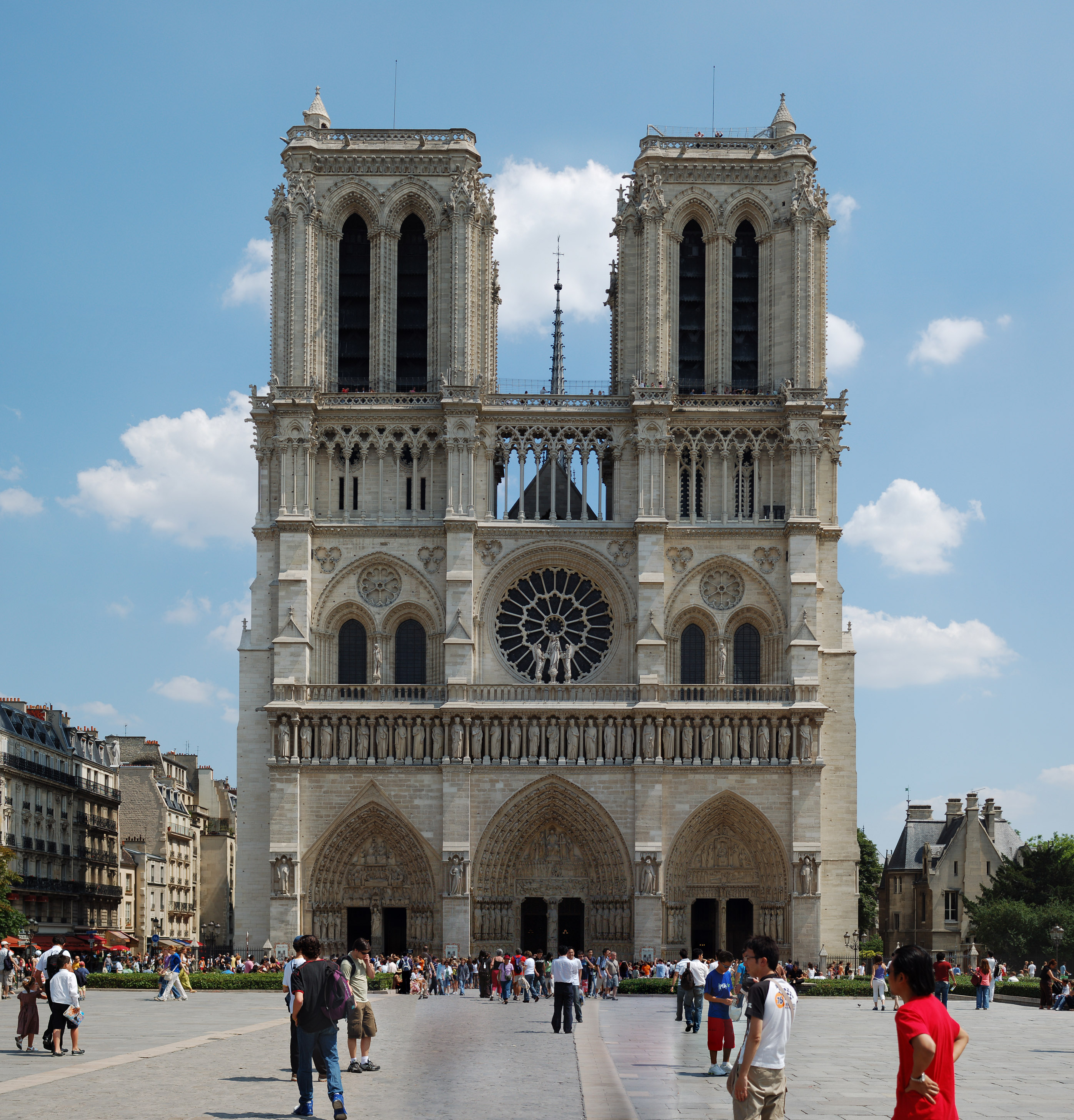
paris has a rich history which gives the city even more culture and identity. and example of this can be the notre dame. this is a major tourist attraction that is intriguing and unique. on a larger scale france has a rich history as well, and this only adds to why paris is such a good place to be. not only is it different in its own way it represents france as a country.
France is known for its exquisite food and drink, especially cheese and wine. when people talk of good wines and delicious cheese, french wine and cheese are always of the best quality and among the most expensive. as paris is the main city in france it is the forefront of this notion and represents the country accordingly. this is another aspect that makes the city unique.
Paris is also known for its amazing architectual structures and its artwork. the Louvre musium in Paris is one of a kind as it holds some of the finest artworks in the world. this included the fabled mona lisa by leonardo da vinci which is probably the most well known and most famous painting in the world in history. even just having the painting in the city makes Paris unique.
Wednesday, March 23, 2011
Urban Sprawl or Consolidation: Jordan Springs
1. this would be an example of urban sprawl as its a completely new suburb that is spreading outwards. it isn't considered urban consolidation because its not building up on other buildings, compacting space and raising the population in a small area. its completely new and is moving outwards.
2. i think there are many good things and many bad things that could happen as an outcome of this development. in the article it says that it creates job opportunities, it's environmentaly friendly and it will have a strong community spirit. the development as a whole would however impact the environment massivly. the natural habititat in the area would be destroyed in the building process, the environment and the ecosystem would be affected massivly and animals will be driven from their homes. this new development also means that more resources will need to be supplied by sydney, such as roads and electricity.
2. i think there are many good things and many bad things that could happen as an outcome of this development. in the article it says that it creates job opportunities, it's environmentaly friendly and it will have a strong community spirit. the development as a whole would however impact the environment massivly. the natural habititat in the area would be destroyed in the building process, the environment and the ecosystem would be affected massivly and animals will be driven from their homes. this new development also means that more resources will need to be supplied by sydney, such as roads and electricity.
Wednesday, March 16, 2011
Urban Planning and Development
1. the term urban sprawl is used to describe a city when it becomes to populated and is forced to spread outwards.
2. the term urban consolidation is used to describe the rising population in cities.
3. a highly urbanised country is a country that has a lot of urban spraw, has a high population density.
4. it is estimated that 92% of australians live in urban areas. australia's urban population is concentrated in major cities, which in 2006 accounted for over 13 million people or 65% of Australia's population.
5. the main factors that have influenced the location's of Australians capital cities are transport advantages, also the flat land that is available and the climate.
6. population density is the population in a particular area divided by the amount of land in the area. population density is related to urban sprawl as it is a solution to the problem. the move from urban sprawl to higher population density in cities is urban consolidation.
7. Australian cities don't have very high population densities. Sydney for example has a population density of 2076 per square kilometre compared to Mumba with a population density of 29650 per square kilometre.
8. there are many advantages that urban consolidation has over urban sprawl. infrastructure like public transport, electricity and water supplies are already built for the developments.
9. urban planners have had to be inovative in their design of apartments and new estates to manage the impacts of population growth in cities.
10. A) Melbourne
B) Population divided by land area
C) Sydney, Melbourne, Adelaide, Woolongong, Perth, Newcastle, Canberra, Brisbane, Gosford
D) 8 out 10 of Australias largest cities have a population density over 1000
11. many of the residents would stronly argue that the development of apartments such as the ones in fig. 9.5 lower the value of their properties. also the constant noise and disruption would be extremely annoying for residents who are trying to live their normal lives.
12. living in a detached housing estate is a lot more private than apartment living as you are on your own property. it also allows you to make the regulations and rules, such as the ownership of pets, etc. having your own property also enables you to design and aesthetically modify your property to the way you like, it allows you to give your home its own character. it is also easier to have a family which many people want. an advantage of living in an apartment however means you are usually closer to civilisation in terms of entertainment, work and other aspects that make up an urban area. sometimes it gives you things like water views over a harbour, landmark, etc.
Urban Renew and Decay
aesthetics - The branch of philosophy that deals with the nature and expression of beauty, as in the fine arts.

this picture expresses various colours, emotions, messages and feelings that all contribute to the overall aesthetical qualities.
safety - The condition of being safe; freedom from danger, risk, or injury.

in this picture the man in the cage is protected by the metal framework from the enormous man eating, great white shark.
slums - A heavily populated urban area characterized by substandard housing and squalor.

this is a picture of a slum located in Mumbai, as you can see it is extremely overpopulated, the houses are very low grade and are made out of thin sheets of metal and finally the good health and cleanlyness of the place is not evident or inviting
decay - To break down into component parts; rot.

decay is evident in this photo as the peice of fruit is rotting.
reconstruction and renewal - is the the rebuilding and renewal of towns and cities that have been demolished as a result of war, natural disasters and other destructive forces.

in this photo the building has been demolished during the war and an attempt to rebuild it is being started.
Transport - To carry from one place to another; convey. transport involves the moving of a particular thing or a group of things from one location to another.
transport examples in this phto are trains, plains, vehicles (bus) and boats. they are all forms of transport.
suburbanization - Of, relating to, or characteristic of a suburb.

in this photo there is an overcrowded suburb which is a characteristic that makes it what it is.
environmental factors - environmental factors are different contributors that affect the environment in different ways.

in this photo an industrial area is producing air polution which is an environmental factor.
Light and Sound - Light and sound are aspects that essentially make up the world we live in. light comes from the sun and enables us to see our surroundings. sound enables us to hear things that are happening. swithout light and sound there would not be a civilisation to live in.

in this photo the police siren is producing blue and red lights and also giving off sound to let everyone in the surrounding area know there is a police car.
Monday, March 7, 2011
7.6 The Tweed River Entrance Sand Bypassing Project
1. it became necessary to extend the tweed river breakwaters due to further sand build-up at the entrance of the heads.
2. The breakwater on the southern side of the tweed river acted to trap sand that would naturally be moved in a northerly direction by longshore-drift. The continual build-up of sand on the southern side of the breakwater eventually caused the river mouth to once again silt up.
3. The dredging of the sand at the mouth of the Tweed River was trucked and moved to the gold coast for beach nourishment. This is an expensive solution and one that would need to occur continually in order to maintain the sand supply to the beaches. The removal of the sand is essential for the ships to be able to get through the tweed river mouth. The natural process that causes sandbars to form is silting.
4. The dredging of the tweed river mouth and associated beach nourishment program was only a short term solution as the silting of sand at the mouth of the tweed river is an ongoing process and this management strategy is just not effective long-term.
5. The TRESBP replaces the natural process known as longshore drift in the construction of breakwaters. This construction breaks the drift of the ocean when it hits the beach as it cannot go past the wall of rock.
6. I believe the TRESBP is one of the most successful projects in Australia for a few reasons. Firstly because the intended aim of the project was to stop silting at the mouth of the Tweed River and to stop the formation of a sand bar. The construction of breakwaters was the best thing that could have been done and did work in stopping the silting – temporarily. Even though it is very costly this project can be used as a learning curve for future projects. It gives developers an idea on what they should do the future, which may be even more beneficial and less costly. I’d say as a whole the TRESBP was very successful.
7. –
8. 1962 – you can see that the Tweed River entrance is extremely vulnerable to the build up of sand known as silting and something needs to be done.
1969 – The construction of the breakwaters has opened the Tweed River heads and caused the beach to shift position. There is more sand on the surrounding beaches as the process of dredging has also taken place.
1994 – The breakwaters haven’t really changed but the amount of sand on the surrounding beaches has increased dramatically. Fairly soon a new solution will need to be put in place as the sand will reach the edge of the breakwater and will once again, begin to form a sandbar.
9. In the topographic map the length of the breakwater is approximately 350 metres in 1994. In 1962 the breakwater was not present.
Monday, February 28, 2011
Year 10: Coastal Management Vocabulary List
CONSTRUCTION WAVES - small low energy waves that deposit sand onto beaches
CORRASION - occurs when waves crash over rock shelves and move rock and other material helping to erode the rock shelf away
CORROSION - the action of salt and minerals like iron that are contained in rock, weakening the rock and making it more susceptable to erosion
DEPOSITION- the depositing of sand and rock particles caused by wind and wave action forming features such as beaches
DESTRUCTIVE WAVES - large waves formed by tropical cyclones and storms that erode material from beaches
EROSION- the removal of rock and sand particles as a result of wind and wave action
FETCH - the distance the wind travels over the ocean to form waves
FOREDUNE - the closest dune to the ocean or the first dune in a sand dune system
HYDRAULIC ACTION - where waves enter cracks in rocks. air is compressed by the force of the water causing erosion and forming features such as blow holes
LONGSHORE DRIFT - the process, caused by waves hitting the coast at an angle, that is responsibe for moving sand along the coast
REFRACTION - the bending of waves around headlands into bays
SURF AND SWASH ZONE - the active part of the coast in terms of erosion and deposition of sand by wave action; the surf zone is immediately adjacent to the coast and the swash zone is at the shore once the waves have broken
VEGETATION SUCCESSION - the natural progression of vegetation from low-lying, salt tolerant plants on the foredune, through to shrubs and established trees on the hind dunes
WAVE HEIGHT - the verticle distance between the trough and the peak of the wave
WAVELENGTH - the horizontal distance between wave peaks
BREAKWATERS - a barrier that breaks the force of wavebefore it enters a harbour or bay
FAECIAL COLIFORM - Aerobic Bacteria Found in the Colon or Faeces, often used as indicators of faecal contamination of water supplies
SILTING - the filling up or raising of the bed of a body of water by depositing silt.TIDAL FLUSHING -
GROUND SWELL - the ground swell is the swell out in the ocean created by the wind
PLUNGING WAVES - break on beaches where the slope is moderately steep. board riders like these waves because of the tubes they form
SPILLING WAVES - break far from the shore on beaches with gentle slopes. the surf gently rolls over the front so these waves are good for body surfing
SURGING WAVES - occur on very steep beaches. the waves roll up the steep face rather than breaking over it. they cause erosion
WIND SWELL - if waves travel only a short distance before they hit land they form a wind swell. a wind swell is marked by a short wavelength and high frequency of waves hitting the coast
AEOLIAN - is another word for wind - aelian transportation of sand is the same as wind transportation of sand
SPINIFEX - spinfex is a type of low-lying coastal vegetation found in the foredunes close to a beach
DREGDING - the mass removal of sand from one place - by humans - to another
ACCRETION CYCLE -
GROYNES - constructed along beaches to catch sand and make beaches wider
REVEGETATION - the replanting of regetation along the coastline
SEA WALLS - used to stop erosion of the coastline and protect property. sea walls often replace the foredune. which is an essential part of the beach erosion
ENVIRONMENTAL IMPACT STUDY - the study of various impacts along the coastline that affect the environment
IMPACT ASSESSMENT - an assessment of the impacts that are affecting the coastline and the environment
BITOU BUSH - is a perennial, dense, sprawling shrub that has recently become an extremely invasive coastal weed
MARRAM GRASS - a perennial grass native to sandy shores along the Great Lakes and Atlantic Coast of North America. it is commonly planted as a sand binder to help stabalise sand dunes.NOXIOUS WEED - a noxious weed is a native or non-native plant that is unwanted in a particular area.
ANEMOMETER - An instrument for measuring wind force and velocity.
HYGROMETER -
Dune Revegetation at Stuarts Point - 7.8 Questions
1. Stuarts Point, which is a small village located on the mid north coast of New South Wales.
2. 1970's - one of the first large-scale beach vegetation schemes in New South Wales was conducted on the sand dunes at Stuarts Point.
1983 - the mouth of the macleay river was just south of grassy headland.
1983 - a large flood cause the macleay river to break through the sand barrier at the south west rocks, creating another entrance for the river.
1965 - the Soil Conservation Service of New South Wales provided native plant seedlings and planting advice to the progress associates of Stuarts Point in what was to be the start of the vegetation program for the dunes.
1970 - a joint venture involving the Department of Lands, the Department of Public Works, The Macleay Shire Council, and the soil Conservation Service of New South Wales was established with the aim of stabilising the sand dunes through a revegetation program.
3. the local community is needed to help stabilise the sand dune system along worth other councils and organisations in the surrounding area. in doing this the local community would help the fishing and tourism industries in the area.
4. the sand dune area at Stuarts point is important because it ensures that the fishing and tourism industries aren't affected and it also ensures that the sea doesn't breach the wall in severe storms like it has done a few times in the past, resulting in the destruction of property and other vegetation.
5. the primary species of vegetation on the beachfront consists of grasses and creepers. the secondary species includes shrubs and short lived trees, highly adapted prolific re-seeders and fast growing plants. the tertiary species at the back of the beachfront includes long lived trees.
6. having vegetation in amongst a sand dune traps the sand so it doesn't blow away. if there is a strong wind and there is no vegetation on the beachfront all the vegetation will be blown away. however, if there is a lot of vegetation in the beachfront the shrubs, plants, etc. all trap the sand which stabilises it and the entire dune doesn't blow away.
7. cattle grazing had a dramatic effect on the dune system as it destroyed all the vegetation. this in tum allowed the wind to blow away the sand and heavy storms to overpower the - now very weak - wall of sand.
8. cattle grazing would have primarily destroyed all living vegetation in the sand dune. this would have allowed things like erosion to happen as the sand is now able to be lifted and blown away. as the sand wall now becomes increasingly fragile the heavy seas also slam against the wall of sand.
9. the groups involved in the rehabilitation program included the Department of Lands, the Department of Public Works, The Macleay Shire Council, and the Soil Conservation Service of New South Wales
10. the first step in the rehabilitation program was the use of a tractor to form a small foredune. on top of this a dune-forming fence was constructed to help trap the wind blown sand and establish a foredune. the next stage involved the planting of trees along the riverbank to stabilise the western margin of the area. and finally, after the planting of the trees was completed, native seedlings were planted into the area between the fordune and the riverbank.
12. the geographical processes that would have caused the macleay river entrance to silt up in 1900 are refraction as the waves would need to bend around the mouth of the river. this would have caused the waves to clash and in turn would create a small underwater sand island over a period of time.
13. a) the stabilising of the sand dunes was extremely successful as the large foredune on the beachfront is now 3-4 metres high and is negligible.
b) the protection of the macleay river system is successful in some ways and not in others. the problem of silting and an unstable sand dune have been conquered but the revegetation project has now introduced a noxious weed known as biteau bush which runs the entire length of the foredune.
c) many groups in the local community have benefited from the revegetation project undertaken at Stuart's point. the community itself is now able to lead their usual lifestyles without worrying about the fishing and tourism industries as much as before. also the knowledge that this management strategy works is beneficial for every group that took a part in the revegetation project. this management strategy is now being used across New South Wales for the benefit of the environment and the surrounding ecosystem.
14. (done in PowerPoint)
Sunday, February 27, 2011
Summarising the TRESB Project
1. during the 1950's the entrance to the tweed river. which is at the southern end of the gold coast, became a hazzard to shipping because of sandbars that were forming across the river mouth. the easy solution to this problem was to construct breakwaters to stabalise the river entrance and help keep it clear of sand. although this solution initially fixed the problem for shipping, it had to be extended again due to firther sand build up.
 2. in an effort to create a safer river entrance and solve the problem of the beaches immediately north of the Tweed being deprived of the natural supply of sand, the accumulating sand at the river mouth was periodically dregded and trucked to the gold coast where it was used for beach nourishment. although this solution was effective and still is effective it also comes at a price.
 3. the tweed river bypassing project provides an example of how people can implement coastal management schemes that re-create the natural processes operating along the coast. the project also involved the cooperation of state and local governments in responding to the communities concerns and opinions. to date it is one of the most successful coastal management strategies implemented in australia. the entrance the to the Tweed River and the beach above it are the two primary aspects of the location that have been heavily affected. i believe that the attempt to remove the build up of sand at the entrance of the the Tweed River heads is a success although it is still very costly. eventually a better long term solution will need to be found.


Wednesday, February 23, 2011
The Science of Big Waves
Pre-viewing:
Question for the Video:
Homework:

Teahupo'o is a reef break. it is mostly left breaking, but when surfers journey to the outer reef there is also some right breaking waves which is extremely dangerous if you get caught up in one. this surfing break is also renound for the tremendous and consistent amount of barrels it provides for surfers. many famous surfers have regarded this location as "a must surf" spot for other enthusiastic surfers who are seeking a challenge.


as you can see the small village of Teahupo'o is located in the south-western area of the island, which is located in the middle of the pacific ocean, halfway between Australia and America.
- Where do ocean waves come from? What gets them started?
- ocean waves come from the action of the wind blowing across them out in the ocean. first the wind forms ripples, then these form wavelets and finally waves. these ocean waves react with the countours of the land and various other aspects that shape the coastal environment when they hit the shore to form one of the three different kinds of waves.
- What do you think a surfer should know about waves before they try and ride a wave while surfing?
- i think a surfer should be familiar with the location that they are surfing in, and the beach that they are at. a good surfer would know the various rips and have enough experience to make good judgements and decisions. it would also be very important to know what types of waves the beach usually has. whether they're spilling waves, plunging waves or surging waves.
Question for the Video:
- Observe all the waves that you see and describe how they form and break. Use as many words found in the segment for you descriptions.
- the "maverick" waves would be classified as plunging waves as they build up coming in from the ocean before they peak and dump over the reef, causing massive swell and huge waves for experienced board riders. most of the other waves in the video are of this same type of wave. they all bend around a reef to meet the countours of the land, and then when they hit the reef shelf their size and ferocity strenghtens significantly.
- Describe how waves are formed, how they originate, and how they are measured?
- waves are formed by the wind out in the middle of the ocean. as the wind blows across the ocean it forms ripples and over a period of time these ripples gradually get bigger forming waves. A wave is measured by three things. its height, the time from crest to crest (wavelength) and the distance between two periods
- What is a maverick wave and what is special about the way it is formed?
- the maverick wave on the north coast of california is special because it is classified as one of the biggest wave breaks in the world. the waves are formed in huge low pressure systems out in the pacific ocean of the coast of alaska. these low pressure systems transfer an enormous amount of energy and give it to the waves through the form of huge storms.
- How is energy stored and transferred during wave?
- the energy in a wave is tranfered through the water, the water itself does not move but instead rotates in a circular motion. as the wave and its energy nears the shore the energy under the wave is compressed by the ever decresing depth of the water. when this happens the pressure builds which causes the height of the wave to go up. when the wave reaches breaking point it surges over in one of three possible wave types - spilling, plunging or surging waves.
- List any kind of advice given by the surfers about how to survive these “big waves.”
- one of the most evident pieces of advice provided by the big wave surfers is to know what your up against, and be an experienced surfer who knows what faces him. inexperience in big wave surfing is one of the most dangerous aspects that could get you seriously injured or killed. another piece fo adivce given by the experienced surfers is to get in on the wave early before the wrath of the waves becomes so fierce its impssible to ride.
Homework:
- Design a blog post on your blog of Maverick waves from different parts of the world. Be sure to describe the geography and the topography of the ocean floor in these areas and how this helps create these massive waves.

Teahupo'o is a reef break. it is mostly left breaking, but when surfers journey to the outer reef there is also some right breaking waves which is extremely dangerous if you get caught up in one. this surfing break is also renound for the tremendous and consistent amount of barrels it provides for surfers. many famous surfers have regarded this location as "a must surf" spot for other enthusiastic surfers who are seeking a challenge.

as you can see the small village of Teahupo'o is located in the south-western area of the island, which is located in the middle of the pacific ocean, halfway between Australia and America.
Saturday, February 12, 2011
7.3 Geographical Processes Shaping the Coastal Environment
1.

2.

Coastal Lagoon
 |
| Tombolo |
 |
| Offshore Sand Bar |
 |
| Sand Dune |
barrier dune system

sand spit
3.

4.

Monday, February 7, 2011


Sunday, February 6, 2011
7.1 Geographical Issues in the Coastal Environment
1. Describe how the settlement pattern of Australia is related to issues in the coastal environment?
- 85% of the Australian population is situated within 50 km's of the coast. this densely populated area has affected the coastal environment in ways such as pollution, tourism, recreational pressures, infrastructure and so on. this settlement pattern is a direct link to the issues that the coastal environment raises.
5. Select four of the geographical issues facing the coastal environment presented in this unit. For each issue identify the human actions that cause the issue.
- population growth - the current Australian trend of people who are moving closer to the coast has cause a rise in infrastructure and over development in certain areas. tourism and recreational pressures - the coast being a very popular place for tourists and residents alike has led to the increase of recreational activities such as beach 4 wheel driving. pollution - from people situated near urban developments along the coastline. the ignorance and lack of respect for the environment from humans has led to the damage of the natural ecosystems situated along the coast. inappropriate development - the greed individual humans have, to get better views and lifestyles along the coastline has led to the destruction of the natural habitat and beauty of the area.
Subscribe to:
Comments (Atom)