high pressure system
2. What is the air pressure in each of the next 4 days for each of the capital cities? How does this correspond with the predicted weather for these cities?
THURSDAY
Sydney - 1020 Hectopascals
Adelaide - 1030 Hectopascals
Melbourne - 1026 Hectopascals
Brisbane - 1018 Hectopascals
Perth - 1022 Hectopascals
Darwin - 1016 Hectopascals
Hobart - 1024 Hectopascals
FRIDAY
Sydney - 1018 Hectopascals
Melbourne - 1027 Hectopascals
Brisbane - 1016 Hectopascals
Adelaide - 1027 Hectopascals
Perth - 1024 Hectopascals
Darwin - 1012 Hectopascals
Hobart - 1024 Hectopascals
SATURDAY
Sydney - 1018 Hectopascals
Melbourne - 1020 Hectopascals
Brisbane - 1017 Hectopascals
Adelaide - 1020 Hectopascals
Perth - 1024 Hectopascals
Darwin - 1012 Hectopascals
Hobart - 1016 Hectopascals
SUNDAY
Sydney - 1016 Hectopascals
Melbourne - 1020 Hectopascals
Brisbane - 1017 Hectopascals
Adelaide - 1020 Hectopascals
Perth - 1016 Hectopascals
Darwin - 1012 Hectopascals
Hoabrt - 1024 Hectopascals


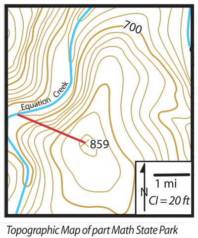
1. What is the contour interval (sometimes abbreviated CI)? Convert to metric.
the contour interval is 20 feet.
2. What is the scale of the map? Convert it into the metric system.
the scale of the map is 1 cm:1.6 kilometres
3. What is the gradient of the line? Calculate in metric system.
121 feet = 36 metres, 2 miles = 3200 metres == gradient is 0.01125